

The climate of the European Alps: Shift of very high resolution Köppen-Geiger climate zones 1800-2100
Abstract
Although the European Alps are one of the most investigated regions worldwide, maps depicting climate change by means of climate classification are still not-existent. To contribute to this topic, a time series of very high resolution (30 arc-seconds) maps of the well-known Köppen-Geiger climate classification is presented. The maps cover the greater Alpine region located within the geographical domain of 4 to 19 degrees longitude and 43 to 49 degrees latitude. Gridded monthly data were selected to compile climate maps within this region. Observations for the period 1800-2010 were taken from the historical instrumental climatological surface time series of the greater Alpine region, HISTALP. Projected climate data for the period 2011-2100 were taken, as an example, from the Rossby Centre regional atmospheric model RCA4. Temperature fields were spatially disaggregated by applying the observed seasonal cycle of the environmental lapse rate. The main results of this study are, therefore, 366 observed and predicted (two scenarios) very high resolution Köppen-Geiger climate maps of the greater Alpine region covering the period 1800-2100. Digital data, as well as animated maps, showing the shift of the climate zones are provided on the following website https://koeppen-geiger.vu-wien.ac.at. Furthermore, the relationship between the Köppen-Geiger climate classification and the altitudinal belts of the Alps is demonstrated by calculating the boundaries of the climate zones, i.e. the deciduous forest line, the mixed forest line, the forest and tree line (timber line) and the snow line. The mean altitude of the potential timber line in the greater Alpine region, for example, was calculated to be 1730 m by the end of the 19th century, 1880 m by the end of the 20th century and to lie between 2120 and 2820 m by the end of the 21st century. The latter altitudes were projected for the greenhouse gas scenarios rcp 2.6 (best case) and rcp 8.5 (worst case). The altitude of the timber line (and the other boundaries of the altitudinal belts) is generally higher in the Western Alps, showing a clear west-east slope.
Citation
Rubel, F., K. Brugger, K. Haslinger, and I. Auer, 2017: The climate of the European Alps: Shift of very high resolution Köppen-Geiger climate zones 1800-2100. Meteorol. Z., 26, 115-125.
Maps

Altitudinal belts vs. Köppen-Geiger climate zones
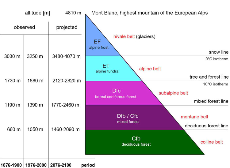
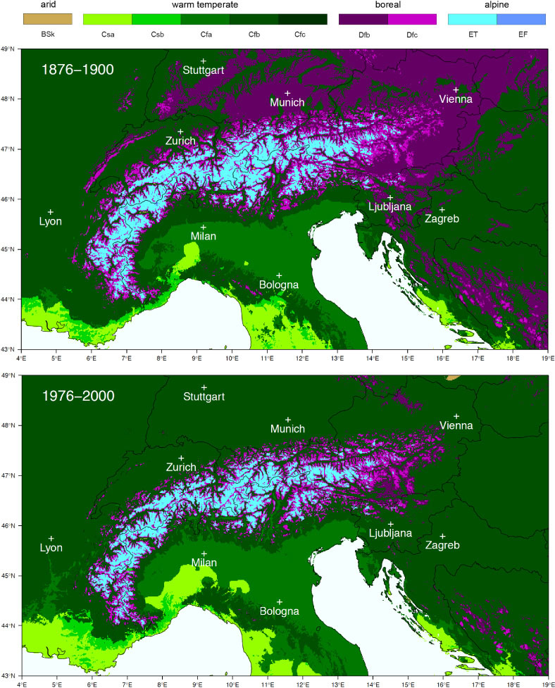
Altitudinal belts of the Alps showing the Köppen-Geiger climate zones together with their boundaries, the deciduous forest line, the mixed forest line, the forest and tree line (timber line) and the snow line. Altitudinal shifts of the lines became visible by comparing the observational periods 1876Ð1900 and 1976Ð2000 as well as the two scenario projections for the period 2076Ð2100. Mean altitudes representative for the greater Alpine region are given. The altitudinal belts of the current climate are comparable to another frequently used, but differently defined classification, which distinguishes between colline, montane, subalpine, alpine and nival belts (red text).
Data
We provide all Köppen-Geiger data files for the period 1800-2100 as raster files, which can easily be read and visualized by the attached Code of the R statistical computing environment (R Development Core Team, 2017). Note, that each climate data file represents a period of 25 years to suppress annual fluctuations. Both, the raster files and the R-code may be used free of charge for non-commercial scientific applications (citation: Rubel et al., 2017). Note the improved colour palette, resulting in slightly different maps compared with those previously presented by Kottek et al. (2006) and Rubel and Kottek (2010).
 code with sample data 1986-2010: Map_KG-Alps.R
Observed Köppen-Geiger files based on HISTALP data, period 1800-1824 to 1986-2010:

Projected Köppen-Geiger files based on SMHI/RCA4 predictions, best case scenario RCP 2.6, period 1987-2011 to 2076-2100:
Projected Köppen-Geiger files based on SMHI/RCA4 predictions, worst case scenario RCP 8.5, period 1987-2011 to 2076-2100:
Selected Google Earth files(.kmz)
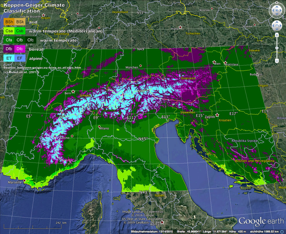
Observed Köppen-Geiger maps based on HISTALP data:
Projected Köppen-Geiger files based on SMHI/RCA4 predictions, best case scenario RCP 2.6:
Projected Köppen-Geiger files based on SMHI/RCA4 predictions, worst case scenario RCP 8.5: